
|
|
|
 |
|||||||||||||||||
|
|
|||||||||||||||||||
|
Rathfriland is a large market village(1) set on a conspicuous hill (506ft) between the Mourne Mountains, Slieve Croob and Banbridge, dominating the plain anciently called Magh Cobha. It takes its name from the large rath or ring fort, which lies towards the east in County Down, Northern Ireland. The name comes from Irish: Ráth Fraoileann meaning "ringfort of Fraoile". Rathfriland lies partly in the parish of DRUMBALLYRONEY, but mostly in that of DRUMGATH, barony of UPPER IVEAGH, county of DOWN, and province of ULSTER. It is within the Banbridge District Council area. Rathfryland(2) was the capital and seat of the petty kings and Lords of Iveagh commanding the entire country for ten miles around. Donal Og Magennis, Lord of Iveagh, founder of the Rathfriland branch of the Magennis family surrendered his lands to King Henry VIII, who granted him a charter to retain his lands and was given a knighthood 1542. His descendant, Art Magennis, 1st Viscount Iveagh, built the castle on the summit of the hill around 1611. The ruins (south gable 30 ft x 25 ft) of the old castle may still be seen at Castle Hill. The castle was formerly very large, being a square building of 3-4 storeys, with a stone barrel vault at the first floor level to reduce the risk of fire. A house was erected on the site in 1812. Whilst digging the foundation, many small cells were discovered, in some of which were found human bones, pieces of armour, coins, and other relics. The town itself was not founded until soon after the Restoration, when in acknowledgement of his services in the parliamentary wars, Charles II granted the whole of the extensive manor to Alderman William Hawkins of London, the first Protestant proprietor here after the rebellion of 1641. The benevolent alderman, at his own cost, provided food, clothing, and lodging for 5000 Protestant royalists, who, during the calamitous progress of the war, had fled to London for protection; collected in England £30,000 for the purchase of corn, wearing apparel, and other necessaries for the support of such as had not been able to effect their escape; and, with the assistance of a few of his friends, raised the sum of £45,000 for the public service and the use of the king. Most of the castle was pulled down by Alderman Hawkins, and the stones used to build the Town Inn (still stands on corner of The Square & Newry Street) and other houses in the town. The town square is located on top of the hill, and a market house (erected around 1764), which dominates the main square. It was built by Theodosia Rathfriland was served by Ballyroney Railway Station, three miles (1) Rathfriland is classified as a village by the http://www.nisra.gov.uk/ NI Statistics and Research Agency (NISRA) (ie with population between 1,000 and 2,250 people). On Census day (29 April 2001) there were 2,079 people living in Rathfriland.
|
|
|
|
|
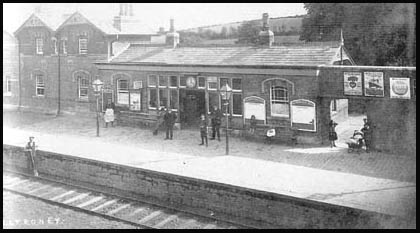 away. The monthly fair in Rathfriland saw of cattle and potatoes unloaded here. Baker's vans waited early in the morning for the bread from
 | Site Map |